Las Minas
Project
- Overview
- Preliminary Economic Assessment
- Location, Infrastructure, and History
- Geology and Mineralization
- Mineral Deposits
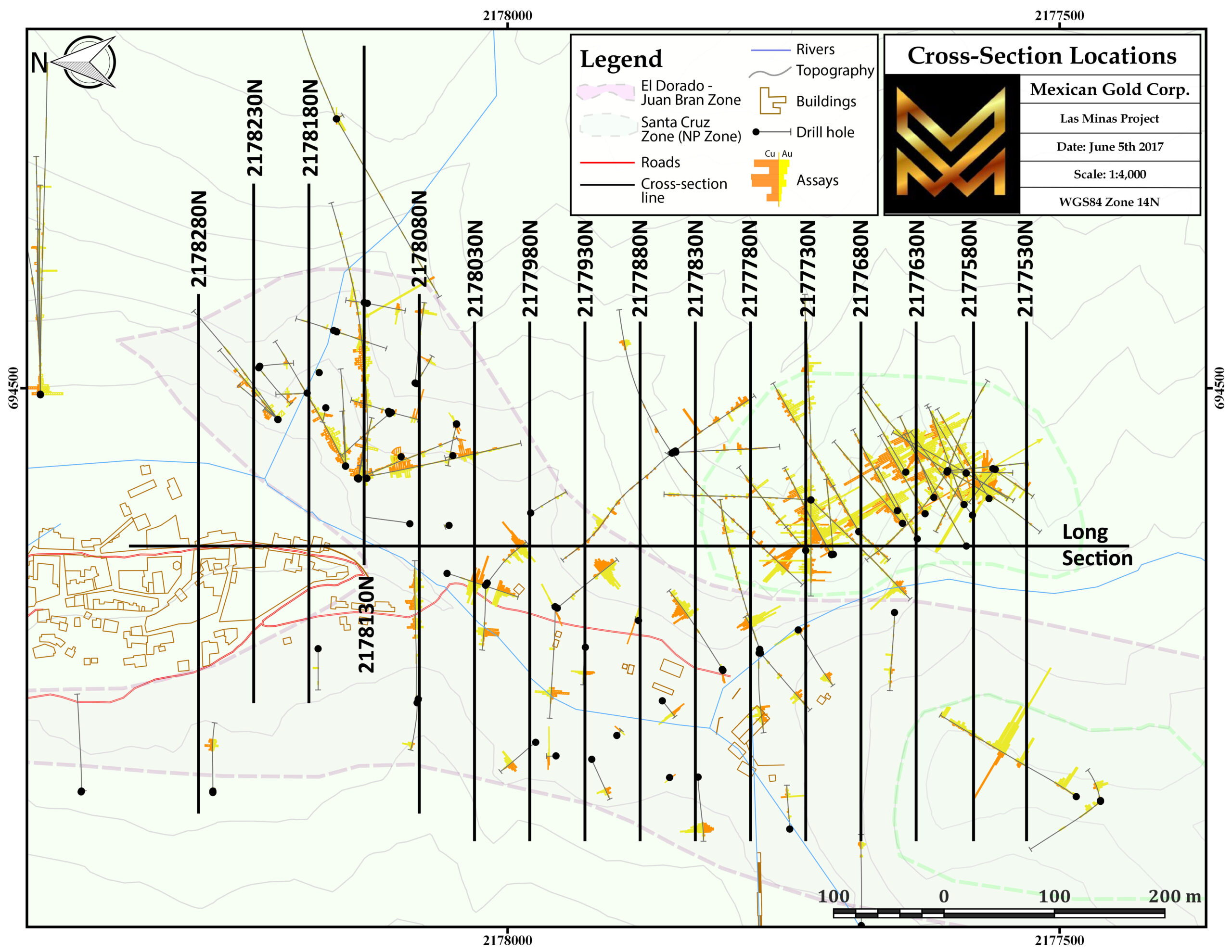
- Drill Sections
Overview
Mexican Gold Mining Corp. controls the entire core of the once-famous Las Minas historic mining district. The canyons of Las Minas (‘mines’ in Spanish) were renowned for their rich copper-gold skarn and vein gold deposits. Applying modern mineral exploration and mining methods in historic mining districts has been a recipe for multiple successes in the two decades since Mexico began opening up to foreign investment.

Gold-Copper
Vast volumes of material which could never have been found, accessed or economically mined with small scale mining operations are now mined as high-grade ore throughout the country. This is the model that Mexican Gold Mining Corp. is well-positioned to develop.
The Las Minas project presently has two gold-copper deposits in advanced-stage exploration, and multiple high-quality, exploration targets. The project area features complete infrastructure, a highly prospective package of regional geology to allow for years of expansion opportunities, a local community enthusiastic for economic development.
The village of Las Minas is within kilometers of a high-speed road and rail corridor. It is 250 road kms from Mexico City and 160kms from the Gulf port of Veracruz. The local area features a small hydro-electric facility, good roads, abundant water and a highly collaborative local labour pool. The project is fully permitted for drilling and up to date for federal and state environmental requirements.
Road & Rail
The gold-copper-magnetite skarn deposits being defined by Mexican Gold are extensions of significant historic mines which once supported the region. As such, both deposits (known for generations as El Dorado and Santa Cruz) are accessible from surface. The form and grade of this mineralization is continuous and well-understood. Metallurgical work has outlined excellent metal recoveries from flotation only, without any requirement for cyanidation processing. Many historic mines in the district remain to be investigated and initial exploration at several locations shows very similar mineralization to the better-known deposits.
Some typical drill results from Las Minas:
Santa Cruz Zone
- 3.57 g/t Au Eq over 99.0 metres in LM-14-SC-08, including
- 7.42 g/t Au Eq over 39.0 metres , including
- 24.11 g/t Au Eq over 9.60 metres
- 7.42 g/t Au Eq over 39.0 metres , including
- 2.24 g/t Au Eq over 87.0 metres in LM-14-SC-07 , including
- 3.13 g/t Au Eq over 49.0 metres, including
- 4.36 g/t Au Eq over 25.0 metres
- 3.13 g/t Au Eq over 49.0 metres, including
- 3.00 g/t Au Eq over 29.0 metres in LM-14-SC- 09 , including
- 5.00 g/t Au Eq over 15.0 metres
- 1.90 g/t Au Eq over 77.0 metres in LM-14-SC-10, including
- 5.1 g/t over 19.0 metres, including
- 6.2 g/t over 15.0 metres
- 5.1 g/t over 19.0 metres, including
El Dorado Zone
- 1.55 g/t Au Eq over 42.5 metres in LM-14-JB-01
- 4.45 g/t Au Eq over 6.0 metres in LM-14-JB-02 Upper Zone including
- 12.67 g/t Au Eq over 2.0 metres, and
- 4.36 g/t Au Eq over 25.0 metres
- 12.67 g/t Au Eq over 2.0 metres, and
- 2.34 g/t Au Eq over 20.1 metres LM-14-JB-02 Lower Zone, including
- 3.10 g/t Au Eq over 15.1 metres
- 1.82 g/t Au Eq over 10.0 metres in LM-14-JB-04
Preliminary Economic Assessment
Mexican Gold Mining Corp. (the “Company” or “Mexican Gold”) (TSX-V:MEX) is pleased to announce a positive Preliminary Economic Assessment (PEA) for its 100% owned Las Minas Project in southeastern Mexico. Summary economic results are as follows:
Las Minas PEA Financial Highlights, including Metal Prices Sensitivity
| Base Case (BC) | Spot Price (Jul 29, 2021) | Upside | Downside | |
| Au (US$/oz) | 1625 | 1830 | 2000 | 1200 |
| Ag (US$/oz) | 20 | 25.5 | 28 | 14 |
| Cu (US$/lb) | 3.25 | 4.45 | 4.75 | 2.25 |
| Magnetite Concentrate (US$/dmt) | 100 | 213.5 | 220 | 65 |
| Cumulative Cash Flow (US$M) | $99 | $237 | $276 | -$22 |
| After Tax NPV @ 5% (US$M) | $55 | $157 | $187 | -$37 |
| After Tax NPV @ 8% (US$M) | $35 | $122 | $148 | -$43 |
| After Tax IRR (%) | 16% | 31% | 35% | -5% |
| Capex Payback (Years) | 4.4 | 2.8 | 2.6 | n/a |
| EBITDA for First Year of Full Production (US$M) | $43 | $70 | $77 | $19 |
Notes:
Metal prices for Upside and Downside cases represent the individual metal historical 3-year highs and lows.
The PEA is preliminary in nature and is based on inferred mineral resources that are considered too speculative geologically to have the economic considerations applied to them that would enable them to be categorized as mineral reserves, and there is no certainty that the preliminary economic assessment will be realized. Mineral resources that are not mineral reserves do not have demonstrated economic viability.
The Company also announces a new mineral resource estimate, prepared in accordance with National Instrument 43-101, of 443,000 gold equivalent ounces within indicated resources of 4.13 million tonnes at grades of 1.96 g/t gold, 4.64 g/t silver, 1.08% copper, 14.77% magnetite and 361,000 gold equivalent ounces within inferred resources of 5.20 million tonnes at grades of 1.44 g/t gold, 5.97 g/t silver, 0.95% copper, 17.54% magnetite, all reported at a US$80 per tonne Net Smelter Return (NSR) cut-off.
Philip O’Neill, CEO and Director of Mexican Gold stated: “We are delighted with the economic results for our Las Minas project which is based off our drilling to date at Las Minas. This PEA study demonstrates robust economics with modest initial capital and positive economic returns for the development of an initial mining operation at Las Minas. The Company believes there is significant resource upside with further drilling at Las Minas both in the immediate area of the existing resource and through exploration of multiple other targets on the mine property. In addition to continuing advancement towards development to production and positive cash flow, the Company will continue to aggressively explore with the objective of building a larger resource base. With success we believe there is good potential to significantly increase the project economics above the base we have now established. There are a number of precedent operations in Mexico that have started at a more modest throughput rate based on an initial resource base and then expanded throughput and cash flow as additional resources have been defined through further exploration. Capstone’s Cozamin mine is one example.”
Exploration Potential of Las Minas
Matt Liard, VP Exploration for Mexican Gold stated: “The resource and stope modelling in the PEA show that there is opportunity to bring further tonnage into the resource and to bring further resource tonnage into the mine plan through infill drilling. Several areas have been identified which show potential for additional tonnes with a tighter drill pattern. In particular, the entire northeast and northwest portions of the El Dorado Zone and almost all of the Santa Cruz Zone require attention, along with multiple smaller discrete enclaves and embayments within the main stoping area.
Near the Las Minas resource (within <1km to the north and northeast) there are several exploration targets on the main El Dorado Zone contact horizon that have only been lightly or partially investigated by drilling. The targets combine either extensive historic mining activity (Cinco Senores and Changarro) or a strong geophysical response (Carboneras) with a geological case for mineral potential. Recent modelling work on the Santa Cruz Zone has provided a breakthrough in the genetic and morphological understanding of this deposit. This new knowledge should allow for much better definition of the existing deposit and highlights the potential for further similar deposits in the area.
The mineral potential of the region is well known, being positioned over an active continental subduction zone. Similar geological features and dozens of mineral showings appear over an area of >100km2 centred on Las Minas, and there is strong evidence that the productive El Dorado contact underlies this entire area. The Las Minas area is also surrounded by various mining districts which show every common type of cordilleran mineral deposit.”
PEA Conceptual Design Summary
The concept for recovery of the Las Minas resource is through multiple underground mining methods at a production rate of 1,400 t/d with the mineralized material being hauled via truck to an underground crusher, where it is then crushed and conveyed to the processing plant. Processing will produce a copper concentrate containing gold and silver. Additionally, the tailings would be processed to recover magnetite. Tailings after magnetite recovery would be de-watered and pumped underground as cemented paste backfill. Tailings not placed as paste would be trucked to the tailings storage facility (TSF). Production at the mine would ramp up in year 1, maintain full production to the end of year 8, and decrease in year 9 as the deposit is depleted.
| Las Minas Resource Exploitation – PEA Highlights and Project Performance | |
| Total Tonnes Mined | 4,043 kt |
| Diluted Grades | |
| Gold | 1.84 g/t |
| Silver | 5.53 g/t |
| Copper | 1.06% |
| Magnetite | 15.7% |
| Mine Life | 8.5 years |
| Average Annual Production | |
| Gold Equivalent Ounces | 45,000 |
| Gold Ounces | 21,000 |
| Silver Ounces | 24,000 |
| Copper Pounds | 9,533,000 |
| Magnetite Concentrate Tonnes | 75,000 |
| Average Cash Cost Per Gold Equivalent Ounce | US$786 |
| Average Cash Cost Per Gold Ounce, Net of By-Product Credits | US$158 |
| Average AISC Per Gold Equivalent Ounce | US$928 |
| Average AISC Per Gold Ounce, Net of By-Product Credits | US$145 |
| Las Minas Resource Exploitation – PEA Highlights and Project Performance | |
| Initial CAPEX | US$90.4 M |
| Sustaining CAPEX | US$54.7 M |
| Processing Plant Recoveries | |
| Gold | 80% |
| Silver | 70% |
| Copper | 90% |
| Magnetite | 90% |
Notes:
LOM Metal Prices – US$1,625/oz. Au, US$3.25/lb. Cu, US$20.00/oz. Ag, US$100/t Magnetite Concentrate
The following is the projected production for the Las Minas project over the expected life of the mine.
Las Minas PEA Mine Production from Indicated and Inferred Resources
| Production Year | Au (K oz) | Ag (K oz) | Cu (M lbs) | Magnetite (k tonnes) |
| 1 | 32 | 57 | 4 | 32 |
| 2 | 29 | 96 | 13 | 79 |
| 3 | 32 | 76 | 11 | 66 |
| 4 | 34 | 65 | 10 | 62 |
| 5 | 31 | 84 | 13 | 66 |
| 6 | 27 | 91 | 13 | 86 |
| 7 | 23 | 108 | 13 | 103 |
| 8 | 23 | 92 | 12 | 94 |
| 9 | 9 | 48 | 6 | 48 |
| Total | 239 | 719 | 94 | 635 |
Notes:
Assumed metal prices over life of mine: Gold US$1,625/oz – Silver US$20/oz – Cu US$3.25/lb – Magnetite Concentrate US$100/t.
Geology
The Las Minas project is located in southeastern Mexico within the eastern portion of the Trans Mexico Volcanic Belt (TMVB), an east-west belt of Miocene to recent volcanic rocks that transects the country from the Pacific coast to the Gulf of Mexico. The pre-Miocene basement in the Las Minas region consists of a sequence of Jurassic and Cretaceous marine sedimentary rocks including sandstone, siltstone, limestone and shale. These have been intruded by Tertiary and Mesozoic plutonic rocks mapped as dominantly granodiorite and porphyritic dacite, with lesser amounts of granite, diorite and tonalite.
Copper and gold mineralization have been recognized in three settings within the Las Minas property: proximal skarn, distal skarn and quartz veins. Proximal-type skarn is the dominant skarn alteration observed within the Las Minas resource zones (El Dorado and Santa Cruz) while distal and gold-bearing quartz veins occur in the exploration targets to the east and north of the Las Minas resources.
Proximal skarn developed along marble-diorite contacts, both as exoskarn developed within the sedimentary rock, and as endoskarn developed within the intrusion. The skarn alteration has a typical zoning of marble-exoskarn-endoskarn-diorite. The distinction between exoskarn and endoskarn can be very difficult because the skarn alteration (especially garnet replacement) can be texturally destructive.
Proximal skarn alteration is dominantly garnet-rich with lesser amounts of pyroxene, and locally garnet appears to have replaced pyroxene. The skarn contains variable amounts of magnetite and lesser sulfide minerals.
Within the Las Minas resource zones, chalcopyrite is the dominant sulfide mineral with lesser amounts of bornite and pyrite. Sulfide grains usually are associated with magnetite and are present as relatively coarse-grained disseminations while sulfide blebs, bands, and veinlets cutting magnetite are also observed. Pyrite occurs as an accessory mineral in the main resource area.
Gold-silver-copper mineralization at El Dorado zone occurs as two horizons that are separated by a barren north-northwest trending diorite dike. The current modeling indicates that the El Dorado skarn zone on the west side of the diorite dike has an 800 m northwest strike length, extends up to 450 m to the southwest away from the diorite dike, is on average 15 to 20 m thick, and can reach over 50 m in thickness along the northwest-striking contact with the diorite dike. In contrast, the El Dorado zone on the east side of the dike has a strike length of 250 m northwest, extends up to 200 m to the northeast from the diorite dike, and is 5 to 10 m in thickness.
The Santa Cruz zone lies about 0.5 km south of the Las Minas pueblo and is well exposed on a west-facing canyon wall just above a tributary of the Rio Las Minas. Skarn within the Santa Cruz zone lies along the west side of the dike, immediately to the south of and stratigraphically higher than the El Dorado zone. The primarily east-dipping mineralization at Santa Cruz is more complex and discontinuous than observed at El Dorado due to the more variable intrusive-marble contact orientations (both near-vertical dike and east-dipping sills).
Mineral Resource Estimates
The mineral resource estimates for Las Minas were prepared to industry standards and best practices and verified by Garth Kirkham, P.Geo., an Independent Qualified Person for the purposes of NI 43-101.
Within the Las Minas Project, 206 drill holes (32,058 meters) supports the mineral resource estimate. The deposit was segregated into multiple estimation domains based on geologic models for each of the mineralized units. The estimated mineral resources occur within the Las Minas gold-copper-silver-magnetite skarn deposit, which consists of the mineralized endo- skarn and exo-skarn units within the El Dorado and Santa Cruz zones. The mineral domains were then used to code the block model, and assays within the modeled domains were evaluated geostatistically to establish estimation parameters. Assays were composited into 2-meter lengths. MineSightTM, a commercially available geologic modeling and mine planning software package, was used to produce a three-dimensional block model while LeapFrogTM Software was utilized to produce the solids models for the estimation domains.
The gold, copper, silver and iron grades were estimated into a three-dimensional, 12 m by 12 m by 3 m block model which was sub-blocked to 0.5 m in three dimensions. Gold (Au g/t), copper (Cu%), silver (Ag g/t) and total iron (Fe%) block grades were estimated from capped composited samples in a single pass. The mineral resources were estimated using ordinary kriging interpolation for the continuous mineralized domains. Search ellipse anisotropy and orientation were guided by the orientation of the domain solids models and omni-directional ellipsoids were employed in the individual zones.
Magnetite estimates were based on applying mathematical regression, as derived from SATMAGAN testing results, to the Total Fe% estimates. A total of 2,601 specific gravity readings were derived from measurements within individual rock types and estimated on a block-by-block basis using inverse distance.
Mineral resources are classified in accordance with the 2014 CIM Definition Standards for Mineral Resources and Mineral Reserves, and the 2019 CIM Estimation of Mineral Resources and Mineral Reserves Best Practice Guidelines.
Mineral Resources are classified under the categories of Indicated and Inferred according to CIM guidelines. Mineral Resource classification was based primarily on drill hole spacing and on continuity of mineralization. There are no measured resources at Las Minas. Indicated resources were defined as blocks with a distance to three drill holes of less than ~30 m to nearest composite and occurring within the estimation. Inferred resources were defined as those with a drill hole spacing of less than ~60 m.
Final resource classification shells were manually constructed on plan sections and all resources are constrained within lithological domains and by the continuous solids. Final Resource classification shells were manually constructed on sections. These interpreted boundaries were created for the indicated and inferred thresholds in order to exclude orphans and reduce potential “spotted dog” effect.
This estimate is also based upon the reasonable prospect of eventual economic extraction using estimates of reasonable operating costs and price assumptions. The mineral resources do not represent an attempt to estimate Mineral Reserves.
The Las Minas resources are reported in the following Table at a base case cut-off of US$80 NSR.
Las Minas Deposit Indicated and Inferred Mineral Resource Estimate at a US$80 NSR
| Class | Tonnes | NSR (US$) | Au (g/t) | Au (‘000 ounces) | Ag (g/t) | Ag (‘000 ounces) | Cu (%) | Cu (‘000 lbs) | Fe Magnetite (%) | Fe Magnetite (‘000 tonnes) | AuEQ (g/t) | AuEq (‘000 ounces) |
| Indicated | 4,133 | 138.58 | 1.96 | 260 | 4.64 | 617 | 1.08 | 98,311 | 14.77 | 610 | 3.34 | 443 |
| Inferred | 5,200 | 112.83 | 1.44 | 241 | 5.97 | 997 | 0.95 | 108,802 | 17.54 | 912 | 2.16 | 361 |
Notes:
- Mineral Resource Statement prepared by Garth Kirkham (Kirkham Geosystems ) in accordance with NI 43-101.
- Effective date: July 27, 2021. All Mineral Resources have been estimated in accordance with Canadian Institute of Mining and Metallurgy and Petroleum (“CIM”) definitions, as required under NI 43-101.
- Mineral resources reported demonstrate reasonable prospect of eventual economic extraction, as required under NI 43-101. Mineral resources are not Mineral Reserves and do not have demonstrated economic viability.
- Underground Mineral Resources are reported at a cut-off grade of US$80 Cut-off grades are based on a price of US$1,700/oz gold, US$20/oz silver, US$3.50/lb copper and US$100/tonne magnetite concentrate and a number of operating cost and recovery assumptions, including a reasonable contingency factor.
- Numbers are
- An Inferred Mineral Resource has a lower level of confidence than that applying to an Indicated Mineral Resource and must not be converted to a Mineral Reserve. It is reasonably expected that the majority of Inferred Mineral Resources could be upgraded to Indicated Mineral Resources with continued
- The Mineral Resources may be affected by subsequent assessment of mining, environmental, processing, permitting, taxation, socio-economic and other
The table below illustrates the sensitivity of the indicated and inferred mineral resource estimate to changes in cut-off grade. The base case at a cut-off grade of US$80 NSR is highlighted in bold. The table suggests that the mineral resource estimate is moderately sensitive to cut-off grade in terms of estimated contained metal.
Sensitivity of Las Minas Indicated and Inferred Mineral Resource Estimate to Cut-Off Grade (base case is highlighted)
| Class | NSR COG (US$) | Tonnes | NSR (US$) | Au (g/t) | Au (‘000 ounces) | Ag (g/t) | Ag (‘000 ounces) | Cu (%) | Cu (‘000 lbs) | Fe Magnetite (%) | Fe Magnetite (‘000 tonnes) | AuEQ (g/t) | AuEq (‘000 ounces) |
| Indicated | >=60 | 5,431 | 122.00 | 1.71 | 299 | 4.27 | 746 | 0.95 | 114,341 | 13.84 | 752 | 2.94 | 514 |
| >=70 | 4,750 | 130.25 | 1.83 | 280 | 4.44 | 678 | 1.02 | 106,373 | 14.35 | 682 | 3.14 | 479 | |
| >=80 | 4,133 | 138.58 | 1.96 | 260 | 4.64 | 617 | 1.08 | 98,311 | 14.77 | 610 | 3.34 | 443 | |
| >=90 | 3,549 | 147.47 | 2.09 | 239 | 4.87 | 555 | 1.14 | 89,467 | 15.31 | 543 | 3.55 | 405 | |
| >=100 | 3,009 | 156.99 | 2.24 | 217 | 5.12 | 495 | 1.21 | 80,326 | 16.19 | 487 | 3.77 | 365 | |
| >=110 | 2,572 | 165.96 | 2.38 | 197 | 5.36 | 444 | 1.27 | 72,146 | 16.86 | 434 | 3.98 | 329 | |
| Inferred | >=60 | 6,769 | 102.84 | 1.32 | 287 | 5.49 | 1,195 | 0.86 | 128,586 | 16.23 | 1,099 | 1.97 | 428 |
| >=70 | 6,012 | 107.69 | 1.38 | 266 | 5.73 | 1,108 | 0.91 | 119,959 | 16.95 | 1,019 | 2.06 | 398 | |
| >=80 | 5,200 | 112.83 | 1.44 | 241 | 5.97 | 997 | 0.95 | 108,802 | 17.54 | 912 | 2.16 | 361 | |
| >=90 | 4,228 | 119.33 | 1.54 | 209 | 6.19 | 842 | 1.00 | 93,057 | 18.00 | 761 | 2.29 | 311 | |
| >=100 | 3,226 | 127.04 | 1.67 | 173 | 6.44 | 668 | 1.05 | 74,354 | 18.24 | 589 | 2.44 | 253 | |
| >=110 | 2,106 | 138.88 | 1.84 | 125 | 7.07 | 479 | 1.14 | 52,930 | 18.42 | 388 | 2.66 | 180 |
Notes:
- Mineral Resource Statement prepared by Garth Kirkham (Kirkham Geosystems ) in accordance with NI 43-101.
- Effective date: July 27, 2021. All Mineral Resources have been estimated in accordance with Canadian Institute of Mining and Metallurgy and Petroleum (“CIM”) definitions, as required under NI 43-101.
- Mineral resources reported demonstrate reasonable prospect of eventual economic extraction, as required under NI 43-101. Mineral resources are not Mineral Reserves and do not have demonstrated economic viability.
- Underground Mineral Resources are reported at a cut-off grade of US$80 Cut-off grades are based on a price of US$1,700/oz gold, US$20/oz silver, US$3.50/lb copper and US$100/tonne magnetite concentrate and a number of operating cost and recovery assumptions, including a reasonable contingency factor.
- Numbers are
- An Inferred Mineral Resource has a lower level of confidence than that applying to an Indicated Mineral Resource and must not be converted to a Mineral Reserve. It is reasonably expected that the majority of Inferred Mineral Resources could be upgraded to Indicated Mineral Resources with continued
- The Mineral Resources may be affected by subsequent assessment of mining, environmental, processing, permitting, taxation, socio-economic and other
Mining Methods
The mining methods proposed are a split of lateral and stoping methods. Long-hole stopes account for 52% of production, 41% from room and pillar, and the remaining 7% from development. Full production of 1,400t/d is achieved in year 2 and sustained for the remainder of the mine life. The design allows for multiple production areas. Stopes are sequenced using a primary-secondary layout and are backfilled using cemented tailings (paste) and development waste rock. Room and pillar areas are mainly mined as a single lift; however, in areas where the mineralization is thicker, multiple lifts might be required. Development waste and lightly cemented tailings are used as backfill in the room and pillar zones as a way of decreasing waste and tailings quantities on surface. The mine will be developed using a conventional mechanized underground mining fleet consisting of development jumbos, longhole drills, bolters, LHDs, and haul trucks. The equipment and operation will be owner operated. Stope optimization and design was based on geotechnical design criteria and a NSR cut-off value of US$90/tonne.
Material Handling
An underground crusher would be located in the upper mining area of Eldorado Zone. Mineralized material would be crushed underground and fed onto a conveyor that crosses the river located near the process plant. At that point, the crushed material would be fed into the mill. Placing the crusher underground would decrease noise on surface and help reduce surface building congestion. Tailings from the process plant would be de-watered and either trucked to the TSF or mixed with water and cement to form paste. Paste would be pumped underground for use as backfill. Binder content varies depending on the mining area being backfilled.
| Mining Method | % of total | Tonnes x 1000 |
| Development | 7% | 279 |
| Long-hole Stoping | 52% | 2,087 |
| Room and Pillar | 41% | 1,677 |
| Total | 100% | 4,043 |
| Development Type | Metres |
| Lateral Development – Waste | 8,426 |
| Lateral Development – Mineralized (includes Room & Pillar) | 20,488 |
| Vertical Development – Waste | 260 |
| Total Development | 29,174 |
Processing
The Las Minas ore responds well to traditional copper flotation strategies, which the mill circuit’s conceptual design is based on. In addition, the high values of magnetite in the ore allow for magnetite recovery from the copper tailings. The mill circuit consists of crushing, grinding, gravity gold recovery, flotation and magnetic separation.
The copper in this deposit is mostly found in chalcopyrite, bornite and chalcocite minerals which tend to float very well. The gold is mostly associated with sulphide minerals and therefore recovers well to the flotation concentrate. The flotation circuit utilizes a primary grind of 150 µm, but the testwork does leave room for a coarser grind to be tested in the future.
The process recovers copper and gold at 90% and 85% respectively, into a copper concentrate with high gold grades (>25 g/t), and magnetite recoveries of over 90%. The magnetite concentrate from the conceptual design would be sold to iron ore smelters, but testwork identified that upgrading to magnetite for dense media separation is possible.
Infrastructure & Tailings Management
The village of Las Minas is within kilometers of a high-speed road and rail corridor. It is 250 km from Mexico City and 160 km from the Gulf port of Veracruz.
Within the resource area, there is a small hydroelectric facility supplied by steel penstock tubes from a reservoir several hundred metres up the ridge. This has been assessed as the most viable and efficient option for power supply of the project while supporting the local power plant. The area has an existing road network, abundant water and a highly collaborative local labour pool.
The conceptual design off the overall project layout considers the natural topography when locating the plant, camp, offices and truck shop, in conjunction with the town of Las Minas.
Tailings generated from mineral processing will be stored in an engineered TSF. Filtered (dry stack) tailings technology will be utilized for removal of free draining liquids from the tailings during operations, and water conservation. Approximately 50% of the generated tailings will be stored on surface in the TSF after removing magnetite and using paste tailings for underground mine backfill. Filtered tailings will be delivered by truck and spread and compacted in the TSF. The facility will be developed in stages over the life of the project and at closure the tailings surface will be covered with a suitable growth media and revegetated.
| PEA – Planned Costs | (US$/t processed) |
| Mining | US$35.83 |
| Processing | US$14.55 |
| G&A | US$7.37 |
| Treatment | US$16.70 |
Metal Prices Sensitivity
| 20% < BC | 10% < BC | Base Case (BC) | 10% > BC | 20% > BC | |
| Cumulative Cash Flow (US$M) | $17 | $58 | $99 | $140 | $182 |
| After Tax NPV @ 5% (US$M) | -$7 | $24 | $55 | $86 | $117 |
| After Tax NPV @ 8% (US$M) | -$18 | $8 | $35 | $62 | $88 |
| After Tax IRR (%) | 3% | 10% | 16% | 21% | 26% |
| Capex Payback (Years) | 7.1 | 5.4 | 4.4 | 3.7 | 3.2 |
| EBITDA for First Year of Full Production (US$M) | $27 | $35 | $43 | $51 | $59 |
Notes:
Base Case metal prices over life of mine: Gold US$1,625/oz. – Silver US$20/oz. – Cu US$3.25/lb. – Magnetite Concentrate US$100/t
Quality Assurance and Quality Control (QA/QC)
All Las Minas project drill and surface samples have been sent to SGS for processing, except for a limited number of second- lab QA/QC check samples that were sent to ALS Minerals. SGS is presently accredited by the International Organization for Standardization (ISO) and has ISO 9001 certification and fulfills ISO/IEC 17025 testing requirements.
Samples were prepared following protocol for mineral sample preparation including weighing, drying, crushing, sieving, splitting, and pulverization. Samples were analyzed for gold and silver using fire assay techniques, and for copper and 33 other elements using inductively coupled plasma – atomic emission spectroscopy (“ICP-AES”) techniques. SGS has used the same analytical methods and procedures for all of Mexican Gold’s drill samples commencing in 2011.
QA/QC samples were inserted into the sample stream sent to SGS on a regular basis for all Mexican Gold drill campaigns. The QA/QC samples consisted of pulp blanks, certified reference materials, and duplicate samples. The duplicates samples consisted of field duplicates (quarter-core splits), preparation pulp duplicates from coarse rejects, and second-lab pulp re- assays. The QA/QC samples have made up about 10% of the total samples analyzed.
Qualified Persons
The scientific and technical data contained in this news release pertaining to the Las Minas Project has been reviewed and approved by the following Qualified Persons, who consent to the inclusion of their names in this release: Gord Doerksen, P.Eng. (Infrastructure, Cost Estimates), Michael Makarenko, P.Eng. (Mining), Michael Levy, P.Eng. (Geotechnical), Garth Kirkham, P.Geo. (Geology, Exploration, Resources), Tad Crowie, P.Eng. (Processing), Ken Embree, P.Eng. (Tailings Management), Tysen Hantelmann, P.Eng. (Economic Analysis), each of whom is independent of the Company.
The scientific information in this news release was reviewed and approved by Sonny Bernales, P.Geo., Senior Geologist and Project Manager for Mexican Gold.
PEA Report
The PEA for the Las Minas Project is in accordance with National Instrument 43-101. The PEA will be filed on SEDAR, within the time frame required under National Instrument 43-101, and will be available at that time on the corporate website.
About Mexican Gold Mining Corp.
Mexican Gold is a Canadian-based mineral exploration and development company committed to building long-term value through ongoing discoveries and strategic acquisitions of prospective precious metals and copper projects in the Americas. Mexican Gold is exploring and advancing the Las Minas Project, which is located in the core of the Las Minas mining district in Veracruz State, Mexico, and host to one of the newest, under-explored skarn systems known in Mexico.
For more information, please contact:
Philip O’Neill – CEO, President, and Director E-mail: info@mexicangold.ca
Website: www.mexicangold.ca
CAUTIONARY NOTES
PRELIMINARY ECONOMIC ASSESSMENT
A preliminary economic assessment should not be considered a prefeasibility study or feasibility study, as the economics and technical viability of the Las Minas Project have not been demonstrated at this time. The Las Minas PEA is preliminary in nature and includes inferred mineral resources that are considered too speculative geologically to have the economic considerations applied to them that would enable them to be categorized as mineral reserves. It cannot be assumed that all or any part of the inferred resources will ever be upgraded to a higher category. Furthermore, there is no certainty that the conclusions or results as reported in the Las Minas PEA will be realized. Mineral resources that are not mineral reserves do not have demonstrated economic viability.
FORWARD LOOKING STATEMENTS
This press release contains “forward-looking information” within the meaning of applicable Canadian securities legislation. Forward- looking information includes, without limitation, information with respect to proposed exploration and development activities and their timing, resource estimates and potential mineralization, the PEA, including estimates of capital and sustaining costs, anticipated internal rates of return, mine production, estimated recoveries, mine life, estimated payback period, net present values, and earnings before interest, depreciation and amortization. Generally, forward-looking information can be identified by the use of terminology such as “plans”, “expects”, “estimates”, “intends”, “anticipates”, “believes”, “potential”, or variations of such words, or statements that certain actions, events or results “may”, “could”, “would”, “might”, “will be taken”, “occur” or “be achieved”. Forward-looking information is subject to known and unknown risks, uncertainties and other factors that may cause the Company’s actual results, level of activity, performance or achievements to be materially different from those expressed or implied by such forward-looking information, including, without limitation, forward-looking statements and assumptions pertaining to the following: uncertainty as a result of the preliminary nature of the PEA and the Company’s ability to realize the results of the PEA, uncertainty regarding the inclusion of inferred mineral resources in the mineral resource estimate and the Company’s ability to upgrade the inferred mineral resources to a higher category, uncertainty regarding the ability to convert any part of the mineral resource into mineral reserves, uncertainty involving resource estimates and the ability to extract those resources economically, or at all, uncertainty involving drilling programs and the Company’s ability to expand and upgrade existing resource estimates, the regulatory process and actions, and those risk factors identified in the Company’s annual information form and management’s discussion and analysis. Forward-looking information is based on the reasonable assumptions, estimates, analysis and opinions of management made in light of its experience and perception of trends, current conditions and expected developments, and other factors that management believes are relevant and reasonable in the circumstances at the date such statements are made. Although the Company has attempted to identify important factors that could cause actual results to differ materially from those contained in forward-looking information, there may be other factors that cause results not to be as anticipated. There can be no assurance that such information will prove to be accurate, as actual results and future events could differ materially from those anticipated in such information. Accordingly, readers should not place undue reliance on forward-looking information. The Company does not undertake to update any forward-looking information, except in accordance with applicable securities laws.
Location, Infrastructure, and History
The Las Minas mining region has been active for centuries. Malachite staining in the white marble cliffs would have been obvious to the earliest observers. Documentation and ruins of mining facilities and former town-sites remain from the early 1800’s. Despite the long history, modern exploration only dates back a decade. Source Exploration initiated diamond drilling in the region in 2011, and the first geophysical surveys in 2012.
The Las Minas project is located 16 km from a high-speed toll highway and rail corridor at Cruz Blanca junction, which by road is another 240km east of Mexico City and 150km west of the port city of Veracruz. The town of Perote (pop. ~35,000) is 10 km from Cruz Blanca and has most supplies and services available. Las Minas village, with 600 inhabitants, supplies plentiful local labour.
Within the resource area, there is a small hydroelectric facility supplied by steel penstock tubes from a reservoir several hundred metres up the ridge. Rural roads provide access to much of the claim area. There is abundant water in the creeks 12 months a year which is free to use. Almost all the land on the claim is privately owned rather than being part of the ejido system and there has been no trouble with surface access. The company owns the land over and above the Santa Cruz deposit.
Though topography is steep in the surroundings of Las Minas, extensive mining has been carried out throughout some of the most challenging areas. At present, all of the targets being investigated offer very easy access, being on level ground near roads. The total relief on the project is just under 800m.
At an altitude of 1400m, Las Minas has a temperate climate, with summer maximum temperatures of 28°C and winter minimums of 4°. The rainy season from June through September is not intense, with stiff showers possible in the late afternoons and over nights. Most exploration activities can be accomplished 12 months a year.
Mexican Gold maintains a friendly, constructive relationship with the local inhabitants and town councils. The company makes regular donations to local schools and town facilities. During exploration programs, Mexican Gold is the town’s largest employer and our employees are proud to be a part of the excitement surrounding the potential revival of the mining traditions of the region.
Geology and Mineralization
The Las Minas area is located at the intersection between the Sierra Madre Oriental volcanic province and the Trans-Mexican Volcanic Belt. The region is locally underlain by a Cretaceous carbonate platform which has been intruded by mid-Tertiary (and younger) sills and dikes. The cretaceous rocks have been covered by up to 200 metres of pyroclastic flows, mostly related to the Trans-Mexican Volcanic Belt, which lies on the southern flank of the region. The whole is underlain by a proterozoic crystalline basement of generally high metamorphic grade.

The package of cretaceous carbonate rocks and plutonic intrusives is the horizon of economic interest. Up to 1000m of its stratigraphy is intermittently exposed by the erosion of deep canyons between the high volcanic plains and the low-lying coastal strip. Many of these canyons mark the presence of structures within the carbonate platform, some of which can be traced for tens of kilometres. The carbonate rocks are relatively pure and only weakly deformed, with locally extensive marble development up to 500m in thickness and skarn of up to 200m when in contact with large volumes of plutonic rock.
The most prominent and economically important intrusive lithology in the Las Minas area is a highly evolved, medium grained dioritic phase composed of calcium-rich plagioclase, generally 10 to 15% hornblende +/- biotite and various Fe-Ti oxides. On the Mexican Gold claims this dioritic rock forms a thick sill underlying the entire claim area, a stock complex over 2km in diameter, and numerous smaller dikes and sills. All of these types of intrusive features have Au-Cu-Ag mineralized skarn and other mineralization styles and commodities associated with them. The historic mines and showings on the Mexican Gold claims are found, regardless of commodity affiliation, over 800m of stratigraphy. The system is interpreted as a mid-crustal, high temperature environment.
Au-Cu-Ag-Magnetite skarn
The predominant Au-Cu-Ag-magnetite skarn is described in detail in the Las Minas Deposits section. Most of the larger historic mines targeted this deposit type. It occurs both on sill and dike contacts where it is respectively thicker or richer. The sill-contact mineralization is centred around the intersection line of steep structures within the carbonate and the contact. Another environment (Santa Cruz, San Antonio) appears as lateral ‘flares’ in prepared ground attached to the interpreted stock complex.
Zn-Pb-Ag skarn
Zn-Pb-Ag skarn mineralization has been sampled on dike contacts in several locations and in one historic mine with over 200m of workings. These showings do not point toward any definitive metals zoning, either vertically or laterally, in the claim area.
One of the larger and better known historic operations (known as La Miqueta) mined multiple narrow, steep, Au-bearing quartz veins within a silicified biotite-carbonate schist developed in limestone just above the major sill contact. Several smaller workings mined quartz veins in narrow structures within the dioritic sill itself proximal to its upper surface, where recent sample assaying up to 54.1g/t and 62.2 g/t Au over 1m have been taken. This deposit type is not yet well-understood, and surface work in the area was only initiated in 2017.
El Dorado
The El Dorado deposit is a consistent, single, flat lying sheet of Au-Cu-(Ag)-magnetite skarn developed on the sub-horizontal contact between the carbonate platform and the regionally extensive dioritic sill described above. The zone is lenticular in cross-section E to W, and has been drilled over an area of >650 by >420m. There is very little variation in the mineral distribution, textures and zoning at El Dorado; only the thickness (4 to 60m, generally 12-30m) and grade varies.
The mineralization is almost entirely confined to prograde garnet-(pyroxene) exoskarn, with ore minerals chalcopyrite +/- bornite replacing magnetite or interstitial to coarse garnet grains. Magnetite occurs massive and as well-defined, sub-planar, contact-conformable, centimetric bands in massive garnet or less commonly as randomly curving banding in diopside. Pyrite is a rare, post mineral phase; pyrrhotite and sulfarsenides are not present. Above the very sharp exoskarn front, the carbonate is invariably marble, with only proximal (<10m) and weak calc-silicate alteration. A common feature directly above the deposit is irregularly distributed late to post-mineral -stage hydrothermal breccia, which penetrates intermineral dioritic and endoskarn dikes and sills as well as marble.
The breccia is generally matrix-supported in brown to green to red fe-carbonate + hematite, and shows multiple stages of activation, and some dissolution textures when in marble. It very rarely contains anomalous Au values.
Santa Cruz
The Santa Cruz deposit is a series of dipping, stacked lenses 8-40m thick, located 100 to 150m above the SE portion of the El Dorado. These mineralized lenses occur within a greater package of exo and endoskarn in a corridor approximately 185m wide by 120m thick by 120m deep. Between the two deposits is marble or inter-mineral endoskarn dikes and sills, much of it lying in the intermittent hyrothermal breccia zone. Santa Cruz is exposed on a steep slope along its entire west side, and continues across a small canyon in to the Nopaltepec target.
Much of the character of the mineralization at Santa Cruz is very similar to El Dorado, though the former features notable sulphide redistribution (both destruction and re-concentration), likely through the action of multiple interpenetrating dikes and sills of calcic dioite and endoskarn.
There is also further suite of silica-poor minerals (olivine-augite-serpentine) proximal to a sheeted dike complex (or stock) which marks the south end of the marble / skarn / mineralization.
This vertically-extensive volume of intrusive rock is virtually identical in chemistry, mineralogy, texture and alteration schemes to the dioritic sill underlying the region, and shows mineralized skarn developed on its north contact.
- Overview
- Location, Infrastructure, and History
- Geology and Mineralization
- Mineral Deposits
- Drill Sections